It’s time to post an update to our TAT-2016 adventure.
Leg 1 from East coast to Arkansas was completed a few weeks
ago. 1400 miles total in 8 riding days. If you do the math that is 175 miles
per day average. If you consider 8 hour riding days that would be 21 mph
average. Trouble is that’s not a real measure of the trip. The 1st day was
short because we rode only about 50 miles round trip to the coast and then back
to Woodrow’s folks where we would launch for real the 2nd day. Day 2
was all 2-lane highway of 300+ miles to get to the start of the TAT, Andrews,
NC where the real fun began. We also had to bypass a good chunk through
Mississippi due to cold weather and running out of time. We plan on catching
the MS section in the future but for now our sights are on Leg 2; Arkansas to
Lake City, Colorado.
Before I go into our Leg 2 planning some news from the
results of Leg 1. I had to add one of my favorite pictures from Leg 1. If you
notice it looks like I must weigh 250 lbs but it’s because I had about 6 layers
of clothes on due to the cool temperatures. I also included a picture of the
state flags I added to the side of my CRF for the states we have currently
ridden on TAT-2016. I will add additional states as we ride towards the West
coast.


Item #1 - If you have been reading my previous Leg 1 posts
you know that Woodrow had a few incidents, the last of which was crashing while
missing a dog. I posted pictures of his injuries and how his protective clothing
really saved his butt. An update to his injuries: after getting home he went to
his general practitioner doctor who did an X-Ray and said nothing was broken.
After several weeks of pain he finally went to a specialist for an MRI and
guess what, it was broken. The specialist said that since it wasn’t a displaced
fracture and he had been walking on it for 3 weeks that he just needed to use
crutches for another 3 weeks and stay off it as much as possible. The picture
below came from the MRI and you can see a bright line to the right of the
“bug”. I assume the bug wasn’t in his leg and was placed there by the MRI
operator. End result is Woodrow has been advised by the other TAT-2016 riders
to use his crutches if he expects to ride Leg 2 in August. It wouldn’t hurt if
he got some more riding experience in the next few months either.

Item #2 – I replaced my cheap riding boots with ones I hope
do a better job of keeping my feet dry in wet environments such as river
crossings. I bought the same type as Woodrow used on Leg 1; Alpinestars Toucan.
I didn’t pay full price for these because they were on sale plus I returned my
leaking boots to Cycle Gear for a full refund. I’ve ridden a couple hundred
miles in them and they are pretty comfortable so have high hopes they do a good
job in the future.

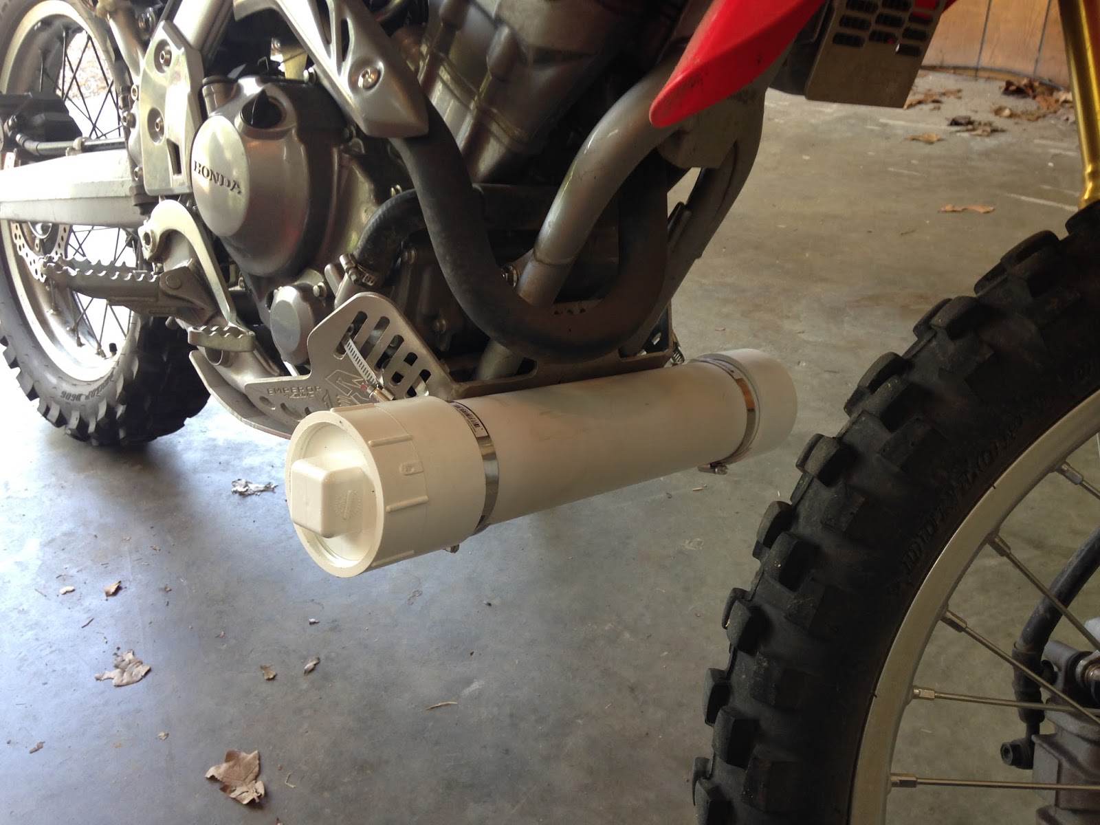
Item #3 – On several occasions I needed tools to tighten up
or adjust something on my bike or more likely Woodrow’s bike but Steve had all
the tools and wasn’t close enough to get him to stop. I decided to carry my own
tools on Leg 2 but needed somewhere to carry the extra weight, preferably low
on the bike. As a side note, I often get on Google when I have spare time and
do a search on Adventure bike pictures. I do this because I have gotten a lot
of good ideas on how to load my bikes or what type of gear to use by looking at
what other riders have used. That is how I discovered the GL line of bags. One
thing I noticed was that some riders use tool tubes in various locations on
their bikes. I made one from PVC pipe and tried several spots on my CRF to see
what may work. I currently have it temporarily attached in front of the engine
skid plate. It seems like it would work there and it does put the weight as low
as possible. Of course it is going to be underwater on any river crossing and
mud is sure to collect there in great gobs. The tube is water tight. Another
possible location is on the left side where the stock took kit and helmet lock
are currently located. They would both have to come off and a custom mount
manufactured but it would be a more streamline design plus just look better. If
I keep it on the skid plate I will shorten it a few inches so if (I mean when)
I drop the bike it won’t hit the ground on the tube. Any suggestions would be
appreciated.

Leg 2 Planning
As you have already read in my previous posts, we used the
paper maps and GPS tracks from Sam Correro for Leg 1 with excellent results
(Link provided below).
We were obviously one of the first to ride the new TAT
section through Georgia and found a couple of problems with the route but it
all worked out OK (details in my previous Blog posts). It certainly takes you
through some challenging but beautiful areas. As a result, I ordered the GPS
tracks for Leg 2 from Sam; states OK, NM and CO. They all loaded seamlessly
into Basecamp on my MacBook Pro and then my Garmin 64ST GPS. The maps from
Basecamp are provided below. Note: Sam provides several separate tracks for the
individual states and I make them alternating red/blue so I know when I need to
load the next track on my GPS.


During our preparation for and completion of Leg 1 we had
ridden a good portion of Arkansas from the east state border to just north of
Russellville, AR. As a result, our official starting point for Leg 2 will be
the red flag north of Russellville on the maps and our end point will be Lake
City, CO where Terry’s family has a cabin; total of 1337 miles. I provided 3
maps in this post and here is why.
Map 1 is of the total Leg 2 route starting in the mountains
(small) in Arkansas and ending in the mountains (large) in Colorado. You’ll
notice a large area in the middle with nothing in it, that’s Oklahoma! I was
raised in the Tulsa, OK area so I can talk badly of OK with immunity. There is
clearly nothing pleasant about riding a motorcycle past Tulsa until you hit the
CO border. The TAT route goes right down the middle of the OK panhandle and
I’ve read on other blogs that it has a lot of sand and just bad roads. I’ve
ridden touring bikes across all the Great Plains (ND, SD, NB, KS, OK, TX) and I
hated it every time due to the wind and boredom. I expect no less on this OK ride
except throw in some sand and that will just mean lots of dropped bikes. But
after looking at my maps for hours, I see no other way around it, OK must be
ridden.
Map 2 is of the CO section through the mountains and the red
dots on the left side are the mountain passes on the TAT route to our Leg 2
destination.
One other point to remember is it took 8 days to ride the
1400 miles on Leg 1 but a good portion of that was on 2 lane paved roads doing
55+ mph. The 1337 miles of Leg 2 are all on the TAT route which I would estimate
to mean much less mph average. We want to accomplish Leg 2 in 9 days if
possible; SSMTWTFSS. We are still working out the shuttle plans of getting to
the start (90 miles from home) and return to Little Rock from Lake City, CO.
This plan at first glance doesn’t look feasible based on our Leg 1 experience.
In addition, we really want to get to CO and have a few days to do some local
riding through passes that are not on the TAT route.
Map 3 is of the section from our Leg 2 start (red flag) to
Bartlesville, OK. This is 324 miles and is a section we are going to ride in
the next month or so thus reducing the total of Leg 2 miles we must ride in
August 2016 to around 1000 miles. If we are successful, we will have time to
ride on a few day trips in CO before we have to head back home to Little Rock.
The spreadsheet below provides a lot of information on our
Leg 2 plans but I must explain the different columns to understand my logic.
SAM column is a number I gave to the paper maps I received
from SAM so they would be in sequence from start to finish. I also use this
number when I name the tracks on my GPS so they are in alphabetical order. SAM
1 through 22 were Leg 1.
State column is the name SAM actually names his individual
paper maps but he starts over with the number at each state border. This makes
it confusing when trying to find which map to use next on the GPS so I named
them all SAM 1 through the end.
Feature column is any town (even near to the route), state
border or highway that the TAT route crossed.
Mile column is the miles I got right off the Sam paper maps.
Sam starts with mile 0 at the east border of very state’s maps. That is why you
see the miles vary so greatly in the spreadsheet.
Dist column is the distance in miles from the previous
feature.
Accum column is the accumulative miles from the start of Leg
2 (red flag north of Russellville, AR).
Notes column is where I think gas or motels will be
available. In some cases Sam made notes on his paper maps for these but in most
cases I just assumed they would be available based on the size of the town.
This is one of the items we will research more in the near future.


As stated earlier, if we are able to do the start to
Bartlesville, OK section in the next month or so then we will be able to do the
last 1000 miles in the 9 days available plus have some local riding time
available. The 9 day window isn’t cast in stone so if we need a few more days
to meet our goals we will work it out.
That’s all I got for now. More as we firm up our plans or
get some significant riding done in the next few months.